
近日,中国矿业大学李志才团队报道了热膨胀对中国大陆GNSS参考站非线性垂直变化的影响。相关论文于2025年12月23日发表在《大地测量与地球动力学》杂志上。
全球导航卫星系统(GNSS)监测墩及地基的热弹性变形是导致GNSS坐标时间序列中垂向非线性变化的重要因素。
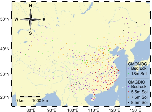
研究组针对基准站监测墩埋深与地基类型的多样性,提出了一个严谨的热弹性效应模型,并利用中国大陆409个GNSS基准站量化了热膨胀对垂向位移的影响。GNSS垂向时间序列、GNSS去除环境负荷(GREL)时间序列与热膨胀效应的周期性特征表明,GNSS去除环境时间序列与热膨胀效应之间具有更高的一致性。中国大陆GNSS基准站的热膨胀年振幅介于0.2毫米至1.9毫米之间,且随纬度升高而增大,呈现南低北高的分布特征。经热膨胀改正后,中国大陆79.2%的基准站振幅呈下降趋势,平均降低0.4毫米。整个中国大陆的加权均方根值平均减少1.1毫米。
改正效果存在显著的区域差异:华中地区改正量最大,西北和华东次之,西南、华南和华北相对较小,而东北地区改正量为负值。热膨胀改正对不同地基类型的基准站表现出相似的改善效果。78.5%的基岩墩站和80.2%的土层墩站振幅有所降低,两者相差1.7%。各类站点振幅变化的平均降低量均为0.4毫米,效果相当。值得注意的是,改正效果随GNSS监测墩埋深的不同而差异显著,其中5.5米土层墩站改正量最大,其次为2米基岩墩站、18米土层墩站和7.5米土层墩站,而8.5米土层墩站的改正效果为负值。
附:英文原文
Title: The impact of thermal expansion on nonlinear vertical variations of GNSS reference stations in Chinese mainland
Author: anonymous
Issue&Volume: 2025-12-23
Abstract: The thermoelastic deformation of Global Navigation Satellite System (GNSS) monuments and foundations significantly contributes to the vertical nonlinear variations observed in the GNSS coordinate time series. A rigorous thermoelastic effect model, which takes into account the diversity of monument depths and foundation types of the reference stations, was proposed in this paper to quantify the influence of thermal expansion on the vertical displacement using 409 GNSS reference stations in Chinese mainland. The periodic characteristics of the GNSS vertical time series, GNSS Removes Environmental Loading (GREL) time series, and thermal expansion effect show a higher consistency between the GNSS Removes Environmental time series and the thermal expansion effects. The annual amplitude of thermal expansion for GNSS reference stations across Chinese mainland ranges from 0.2 mm to 1.9 mm, increasing with latitude, with a characteristic distribution of lower values in the south and higher value in the north. After applying thermal expansion corrections, 79.2% of the reference stations across Chinese mainland exhibit a decreasing trend in amplitude, with an average reduction of 0.4 mm. The average reduction in WRMS across Chinese mainland is 1.1 mm. Regional variability in the correction effects is significant: the largest corrections occur in Central China, followed by Northwest China and East China, while corrections in Southwest China, South China, and North China are comparatively smaller, and the corrections in Northeast China are negative. The thermal expansion correction demonstrates similar effectiveness across different types of foundational reference stations. A reduction in amplitude was observed in 78.5% of bedrock monument stations and 80.2% of soil monument stations, with a difference of 1.7% between the two. The average reduction in amplitude variation for different types was the same at 0.4 mm, indicating a comparable effect. Notably, the correction effect varies significantly based on the burial depth of the GNSS monuments, with the largest correction observed for the 5.5 m soil monument stations, followed by 2 m bedrock monument stations, 18 m soil monument stations, and 7.5 m soil monument stations. The correction effect for 8.5 m soil monument stations is negative.
DOI: 10.1016/j.geog.2025.09.012
Source: https://www.sciencedirect.com/science/article/pii/S1674984725001028
Geodesy and Geodynamics:《大地测量与地球动力学》,创刊于2010年。隶属于爱思唯尔出版集团,最新IF:2.4
官方网址:https://www.sciencedirect.com/journal/geodesy-and-geodynamics
投稿链接:https://www2.cloud.editorialmanager.com/geog/default2.aspx